Aiguillette des Posettes: The Must-See Hike
Publication date : 28 July 2026
Perched at an altitude of 2,201 meters, the Aiguillette des Posettes is one of those hikes that perfectly captures the spirit of the Chamonix Valley: discover breathtaking views and that unique feeling of standing on the balcony of Mont Blanc. We’ll take you along the trails to tell you everything: elevation gain, duration, viewpoints, practical tips… Follow the guide!
Key Takeaways
- An accessible high-altitude hike: summit at 2,201 m, 740 m of elevation gain from the Col des Montets, 8 to 9 km round trip, taking 4 to 5 hours to complete. Moderate difficulty, with no technical sections, suitable for families with children ages 8–10 and up.
- A 360° panorama of Mont Blanc: from the summit ridge, unobstructed views of the Mont Blanc massif, the Aiguilles Rouges, the Chamonix valley, and the Glacier du Tour. This is the main reason why this hike is considered a must-do in the valley.
- Two possible starting points: the most common is at Col des Montets (1,461 m, accessible by car or bus from Chamonix), or from Vallorcine for a longer and more rugged route.
- Best time to go: June through October, depending on snow conditions. July–August for stable but busy conditions; September for tranquility and fall colors. In winter, the route becomes a snowshoe hike reserved for equipped and experienced hikers.
- Key preparation: set out early (light, crowds, afternoon thunderstorms), bring at least 1.5 L of water (no water sources along the route), layers of clothing, sunscreen, and sunglasses. Possible variations via the Refuge de la Boerne or the loop through the village of Le Tour.
Why is the Aiguillette des Posettes so popular?
It’s no coincidence that this hike appears on every Mont Blanc hiking list. The Aiguillette des Posettes checks all the boxes: there’s a well-marked trail, a reasonable elevation gain, and, above all, an absolutely spectacular 360° panorama once you reach the summit.
From the ridge, you have a breathtaking view of the Mont Blanc massif on one side and the Aiguilles Rouges on the other. Below, the Chamonix valley stretches out with its villages, forests, and the Glacier du Tour as a backdrop. It’s the kind of view that leaves you speechless and makes you forget the effort of the climb. Honestly, it’s one of the most beautiful spots in Chamonix (and we mean that!).
Another advantage of this route is that it remains accessible to a wide range of people. You don’t need to be a mountaineer to enjoy it: from families with children (ages 8–10 and up, depending on their hiking experience) to experienced hikers, there’s something for everyone.
Detailed route: from Col des Montets to the summit
The starting point
The hike usually starts at Col des Montets (1,461 m), which is easily accessible by car or bus from Chamonix. Parking is available on site, but it fills up quickly during peak season (so be sure to arrive early to secure a spot!). There is also another option: starting from the village of Vallorcine, which lengthens the route slightly but offers a different and equally enjoyable approach.
The characteristics of the hike
Here is the most important information you need to properly prepare for your outing:
- Elevation gain: approximately 740 meters from Col des Montets
- Distance: 8 to 9 km round trip
- Duration: allow 4 to 5 hours total (ascent + descent)
- Difficulty: moderate; the trail is steep in places but does not include any technical sections
- Summit elevation: 2,201 meters
The course of the ascent
The trail begins with a gentle climb through a beautiful forest of larch and spruce trees. This is the shadiest part of the route, perfect for warming up at a leisurely pace. You’ll likely spot a few marmots—they’re particularly abundant in this area!
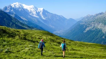
As you emerge from the forest, the landscape suddenly opens up. You arrive at magnificent alpine meadows with the first panoramic views of the valley. This is where the climb becomes a bit steeper, with a few challenging switchbacks. Nothing insurmountable, but keep a steady pace and stay well-hydrated.
The final few meters before the summit ridge are the most rewarding: with every step, the view opens up a little more. And when you reach the summit of the Aiguillette des Posettes, the spectacle is breathtaking. Mont Blanc towers directly ahead, majestic, surrounded by its peaks. Take a moment to catch your breath, sit down, and enjoy the view. You’ve earned it!
When is the best time to go on this hike?
The best time to climb the Aiguillette des Posettes is from June to October (depending on snow conditions). Early in the season, there may still be snowfields on the upper sections of the route: in this case, hiking poles are strongly recommended.
Summer (July–August) offers the most stable conditions, but it is also the busiest time of year. If you prefer peace and quiet, aim for September instead: temperatures remain pleasant, autumn colors begin to appear, and the trails are considerably less crowded.
In winter, the route transforms into a superb snowshoeing outing in Chamonix. The atmosphere is then radically different (muffled silence, pristine snow, and low-angled light), but you must be properly equipped and well-informed about snow conditions.
Our practical tips for getting the most out of it
To make sure your outing is a success, here are a few tips:
- Set out early in the morning: you’ll enjoy beautiful light, less crowded trails, and avoid the afternoon thunderstorms that are common in the mountains during the summer.
- Bring enough water: there are no water stations along the route (allow at least 1.5 liters per person).
- Dress in layers: even in summer, the wind can blow strongly on the ridge, and temperatures drop quickly at high altitudes.
- Don’t forget sunscreen and sunglasses: at over 2,000 meters, UV radiation is intense.
- Check the weather forecast before you go: in the mountains, conditions change quickly. A clear sky in the morning can turn into a storm within a few hours.
A few options for your hike at Les Posettes
The southern route and the Boerne Shelter
Instead of heading back down the same way, you can follow the ridge south toward the Refuge de la Boerne, a charming stop that lets you extend your hike through more rugged terrain. This short detour adds about an hour to the hike, but it’s well worth the effort.
The trail runs along a ridge with sweeping views of the valley to the north and Haute-Savoie to the south. Be careful, though: in wet weather, some sections of the trail can be slippery. Adjust your pace accordingly!
The Tour Loop
For hikers looking for a more challenging hike, the loop that ends in the village of Le Tour is the best option. This moderately difficult trail takes you through the alpine meadows at the bottom of the valley before reaching the gondola. Expect a total walking time of about 6 hours. It’s neither too easy nor too difficult—it strikes the perfect balance, offering the ideal little adventure to see the sights without being in a crowd.
Plan your route with the right tools
Before you set out, download the GPX track for your route and check the IGN map of the area. You can find this information on specialized hiking websites (be sure to read reviews from other hikers to get some real-world feedback). Thanks to everyone who shares their stories online: it’s thanks to them that we can all plan our outings with confidence!
Make the most of your stay in Chamonix
The Aiguillette des Posettes is a great starting point for exploring all the beauty of the Chamonix Valley. If you’re in the area for a few days, take the opportunity to visit the Mer de Glace and explore the ice cave in Chamonix: two complementary experiences that will give you a new perspective on the mountain range. And to explore further afield, check out our selection of the most beautiful villages in the Alps, some of which are just a stone’s throw from Chamonix.
After a good day of hiking, nothing beats a moment of relaxation at a Chamonix spa to soothe your muscles and prolong that feeling of well-being. Book a stay at a Chamonix spa hotel to combine comfort, relaxation, and proximity to the region’s most beautiful trails. It’s the guarantee of a mountain getaway you’ll remember for a long time!
FAQ
What specific gear is recommended for hiking at Aiguillette des Posettes?
For this hike to the Aiguillette des Posettes, we recommend wearing sturdy hiking boots suitable for the sometimes steep terrain. Hiking poles can be useful, especially early in the season to help navigate snowfields. Also remember to pack layered clothing to adapt to temperature changes at higher elevations, as well as a hat, sunscreen, and sunglasses to protect yourself from strong UV rays.
What kinds of animals can you see on the hike to Aiguillette des Posettes?
On the way up, you’ll often have the chance to spot marmots, which are very common in this area. It’s also not uncommon to encounter other mountain animals, such as chamois or birds native to the Alps, especially as you leave the forest and reach the mountain pastures.
How can I get to the starting point of the hike to Aiguillette des Posettes without a car?
The starting point at Col des Montets is accessible by bus from Chamonix, notably via the regular bus routes of the Chamonix Valley network. This allows you to easily reach the starting area without needing a car, which is particularly convenient during peak season when parking lots fill up quickly.
What are the differences in scenery between the ascent via the Col des Montets and the one via the village of Vallorcine?
Starting from the village of Vallorcine adds a bit of distance to the hike but offers a different view of the mountain and a more immersive experience of the wilderness before reaching the Aiguillette des Posettes. The ascent from the Col des Montets, which is more direct, begins in the forest and quickly opens up onto the mountain pastures, whereas the route from Vallorcine offers a more varied journey.
What specific precautions should you take when hiking in winter at Aiguillette des Posettes?
In winter, the route becomes a snowshoe hike, requiring proper gear: suitable snowshoes, warm and waterproof clothing, and poles. It is crucial to be aware of snow conditions to avoid avalanche risks and to stay on marked trails. Caution and a steady pace are essential, as the atmosphere and conditions can be very different from summer, often with more snow and slipperier terrain.